


Lincoln Highway Association
Click the following links to learn more.
How the Lincoln Highway came to be . . .
How to follow the Lincoln Highway through Wyoming . . .
What to see along the Lincoln Highway in Wyoming . . .
THE LINCOLN HIGHWAY IN WYOMING
 The Lincoln Highway Association was established in 1912 for the singular purpose of establishing, “… a continuous improved highway from the Atlantic to the Pacific,” the nation’s first transcontinental automobile road. The LHA, a private enterprise without government funding or support, further specified that the Lincoln Highway would connect New York and San Francisco on a line, “… as direct as practicable considering the limitations of Nature and topography.”
Those words dictated that the Lincoln Highway would breach the Rocky Mountain barrier, the Continental Divide, through a natural, 100-mile wide, gap in the mountain chain that existed only in southern Wyoming. Covered wagon pioneers on the Oregon and California trails in the mid-1800s called this gap “the Great South Pass” and followed the Sweetwater River up gentle slopes to its 7,400-foot summit. In 1867, the Union Pacific Railroad surveyed a southerly route through the pass, more interested in the region’s vast coal deposits than water. The Lincoln Highway would follow the more direct Union Pacific route. Politicians and power brokers in Denver were furious at being left off the “America’s Main Street,” as were citizens of such major cities as St. Louis, Indianapolis and Kansas City. Even Detroit and Chicago were bypassed as the Lincoln Highway stuck to its “direct as practicable” commitment.
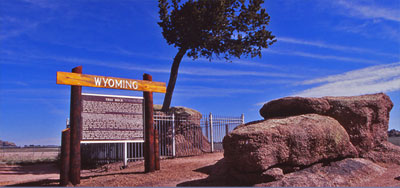
Wyoming officially welcomed the Lincoln Highway on October 31, 1913 at a ceremony in the capitol city of Cheyenne. The town memorialized the event by naming its main thoroughfare “Lincolnway”, a name that still identifies the old railroad and ranching community’s historic downtown district. Wyoming was now open to automobile tourism, a concept unheard of in the days prior to the Lincoln Highway. The Lincoln Highway was created to free automobile travelers from the confines of their urban environments, providing them a way, and a reason, to venture out toward distant horizons. Wyoming fit that concept perfectly. Very soon connecting roads would give Lincoln Highway travelers access to Yellowstone National Park, Jackson Hole, the towering Teton, Wind River, Snowy and Big Horn mountain ranges, Devil’s Tower and the state’s abundance of wide-open spaces.
The Lincoln Highway would experience many changes in Wyoming as the road was improved and shortened over the early years of the 20th century. It would evolve into US 30 in the late 1920s and Interstate 80 in the 1960s. Today, as the Lincoln Highway approaches its Centennial Birthday, it retains its historic identity as America’s Main Street, the nation’s first, and still its major, coast-to- coast transcontinental thoroughfare.
FOLLOWING THE LINCOLN HIGHWAY THROUGH WYOMING
 Interstate 80 is the modern evolution of the Lincoln Highway across Wyoming from Pine Bluffs on the east to Evanston on the west. Travelers on I-80 will be in the Lincoln’s original corridor and in visual contact with the old road for most of the Interstate route.
To stay in closer touch with the historic road, follow the older sections of US-30 where ever they can be found. Look for the Business Loops through the towns such as Pine Bluffs, Cheyenne, Laramie, Rawlins, Rock Springs, Green River, Lyman, Fort Bridger and Evanston. A wonderful intact section of US-30 still exists between Laramie and Wolcott Junction including the towns of Bosler, Rock River and Medicine Bow. The original Lincoln Highway road grade wanders in and out of this stretch of US-30 for 100 miles. Another short section of old US-30 gives access to the historic Lincoln Highway Summit between Cheyenne and Laramie, the 8,835-foot highest point on the original road. Exit I-80 at the Vedauwoo interchange, Exit 329, and follow the service road north and west to rejoin I-80 at Exit 323, the Summit Rest Area Interchange.
Adventure travelers not afraid of getting their tires dirty can still follow actual Lincoln Highway routes in many places in Wyoming. Much of the original road is still in use as maintained county roadways between Pine Bluffs and Cheyenne, Cheyenne and Laramie, Laramie and Rawlins, Green River and Lyman and Fort Bridger and Evanston. Other sections exist as two-tracks and old automobile trails, much as Lincoln Highway travelers experienced in 1913. Anyone interested in following the original Lincoln Highway in detail should research the various maps and guidebooks available from the
national Lincoln Highway Association.
HISTORIC SITES ALONG WYOMING’S LINCOLN HIGHWAY – EAST TO WEST
Pine Bluffs: The Lincoln Highway intersected the old Texas Trail (remember Lonesome Dove?) in this vicinity. A monument at the town’s park and museum marks the event. The town is also a center for Wyoming Plains Indian archaeology. More . . . (link to Pine Bluffs community description, Laramie County page)
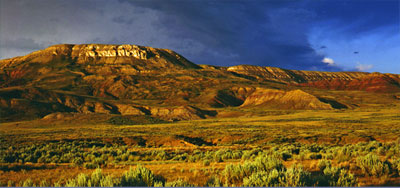
 Cheyenne: The classic Union Pacific Depot (Link to Historic Cheyenne Union Pacific Railroad (UPRR) Depot & Museum on Laramie County page, under Communities) is the centerpiece of downtown Cheyenne, just off Lincolnway. It is a reminder of how closely the Lincoln Highway is tied to the transcontinental railroad’s route throughout Wyoming. Across from the depot is the Plains Hotel, a Lincoln Highway crown jewel restored to its 1911 glory. Cheyenne Frontier Days (Link to Cheyenne Frontier Days on Laramie County page, under Communities), an established annual event by 1913, was mentioned in every Lincoln Highway guidebook. “The stranger should not miss this... The romance of the wild western life is fading away, until scarce a remnant is left for the traveler to see,” according to the 1916 Complete and Official Road Guide. More . . .
The Gangplank: West of Cheyenne the Lincoln Highway climbs to the summit of the Sherman Mountains via The Gangplank, a natural land bridge between the Great Plains to the east and the front range of the Rocky Mountains to the west. This natural feature had much to do with selecting the original route of the Union Pacific Railroad as well as that of the Lincoln Highway and Interstate 80.
 Tree in the Rock: West of Buford in the median of I-80, site access from the left lane. This unique little pine that seems to grow out of solid rock was a curiosity to passengers on the Union Pacific and became a major attraction for travelers on the Lincoln Highway. Postcard photo anyone?
Ames Monument: (Exit 329) This towering granite pyramid was built alongside the Union Pacific at the summit of the Sherman Mountains to honor the railroad’s chief financiers, Oaks and Oliver Ames. The railroad moved its tracks away from the site in 1901 and the monument was abandoned until the Lincoln Highway, making use of the old railroad grade, came along in 1913. It became a major Highway landmark.
I-80 Summit Rest Area: A monumental bust of President Abraham Lincoln dominates this lofty mountain landscape. Sculpted by University of Wyoming art professor Robert Russin, the monument originally was located atop the hill to the west at the highest point on the Lincoln Highway and was moved when Interstate 80 replaced the older road. Next to the Lincoln Monument is a Lincoln Highway memorial to Henry B. Joy, first president of the Lincoln Highway Association and president of the Packard Motor Car Company.
Telephone Canyon: West of the Summit, I-80 enters Telephone Canyon, site of Wyoming first major state highway construction project. Road workers built the Lincoln Highway through this tight little canyon in 1919-20 in an extraordinary feat of engineering that shortened and very much improved the trip between Cheyenne and Laramie.
 Laramie: The University of Wyoming Geology Museum, the Laramie Plains Museum in the old ivinson Mansion and the restored Union Pacific depot are highlights. Visit the Wyoming Territorial Prison State Historic Site, the only place where Butch Cassidy ever did time. More . . .
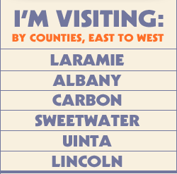
Laramie Plains: US-30, 287 north from Laramie crosses the Laramie Plains, a high altitude grassland that was a hotbed of early Wyoming cattle ranching. The Plains extend from the Sherman Mountains on the east to the distant Snowy Range on the west and from south of Laramie north to Bosler and Rock River.
Como Bluff: In the late 1800s, the world’s first major dinosaur graveyard was discovered at Como Bluff, the major hill north of the highway. A decade of active digging produced tons of petrified dinosaur skeletons, including many previously unknown species. Como Bluff bones were shipped to museums throughout the world. A small stone cabin, made entirely of dinosaur bone fragments, stands beside the Lincoln Highway. Robert Ripley’s “Believe it or Not” named it, “The oldest cabin in the world.”
Medicine Bow: This is the setting for Owen Wister’s classic western novel, “The Virginian,” as well as the movie and television series the book spawned. Another classic is the 1911 Virginian Hotel, a Lincoln Highway landmark that stands as a monument to its original owner’s successful attempt to route the Lincoln Highway through Medicine Bow. More . . .
Hanna: The coal mines near Hanna have been actively producing fuel since the earliest days of the Union Pacific Railroad’s construction. The ready availability of coal found throughout southern Wyoming was a major factor in the selection of the transcontinental railroad’s original route. More . . .
Wolcott: The sheep shearing sheds and pens that stand beside the railroad tracks produced world record amounts of wool during the early Lincoln Highway years. While cattle dominated Wyoming’s eastern plains, sheep ruled the high desert country of south-central Wyoming.
North Platte River: The old Lincoln Highway and US-30 steel bridge stands just north on the present bridge on I-80. Originally, Lincoln Highway motorists made use of the Union Pacific railroad bridge -- with the help of the station agent. Old Fort Steele Crossing Site on Carbon County page under Communities), a supply point during the Plains Indian Wars, stands to the north.
Sinclair: Originally called Parco, this classic “company town” was built in Spanish Mission style by the Producers and Refiners Corporation to support its southern Wyoming operations. The corporation failed during the Great Depression and the town and refinery were acquired by Sinclair in the 1940s. More . . .
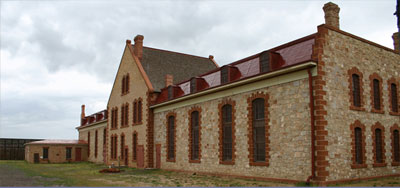
Rawlins: The historic Wyoming Frontier Prison (Link to Wyoming Frontier Prison, Carbon County page under Communities) is an attraction fitting the town’s colorful outlaw past. Big Nose George Parrott was one of those outlaws, a not very successful train robber. He was caught, tried, sentenced to hang and attempted to escape. Caught again, he was lynched by irate Rawlins citizens. For some reason a doctor, later to become Wyoming’s first elected Governor, skinned Big Nose George and turned his hide into various artifacts, including a pair of shoes still on display at the Carbon County Museum. More . . .
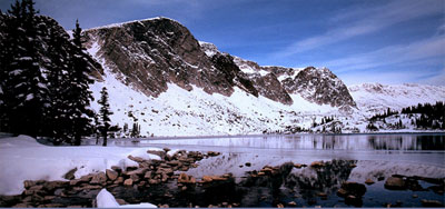
Great Divide Basin: West of Rawlins travelers enter the Great Divide Basin, a “hole” in the Continental Divide that drains to neither ocean. The Atlantic Rim of the Basin is crossed as the highway climbs the low hill west of Rawlins. The Pacific Rim is reached about 60 miles west near the Tipton exit.
Henry Bourne Joy: Located at the Continental Divide Road Exit 184 are informative signs marking the original site of the Henry Bourne Joy Monument (now located at the I-80 Summit Rest Area) and the Great Divide Basin. Joy is recognized as the founding father of the Lincoln Highway and said that its creation was the “…most important thing I ever did.” President of the Packard Motor Car Company, he traveled the Lincoln Highway many times and had a particular love for the high desert country of Wyoming’s Great Divide Basin.
Point of Rocks: The Lincoln Highway merges with the older Overland Stage Trail at Point of Rocks. The Overland Trail was opened in 1862 by “Stagecoach King” Ben Holladay as a shorter, safer alternative to the 1843 Oregon Trail. Most of the Point of Rocks Station has been restored or preserved as a State Historic Site. More . . .
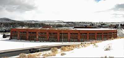
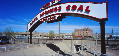 Rock Springs: First, foremost and always a mining town, the story of Rock Springs is best told at the local museum. Of interest is the restored “Home of Rock Springs Coal” welcome arch sign that once spanned the Lincoln Highway and now stands adjacent to the Union Pacific depot. More . . .
Green River: The first expedition to explore the Green and Colorado River systems and the Grand Canyon was launched from Green River in 1869. John Wesley Powell led a nine-man crew in four wooden boats into the unknown wilderness on the ultimate river float trip. Powell and five crewmen survived the trip. The event inspired the creation of the U. S. Geological Survey, with Powell as the first Director and the father of the nation’s reclamation movement. The grand adventure is commemorated at Expedition Island in the town of Green River. More . . .
Palisades: The Lincoln Highway, US-30 and I-80 share a narrow corridor between the Green River and the towering Palisades in one of the beauty spots of southwest Wyoming. Western artist Thomas Moran painted the Palisades in the late 1800s and the scene is little changed save for the fact that I-80 now tunnels under Castle Rock and loops around the back side of Tollgate Rock.
Granger: The Lincoln Highway angled northwest of present I-80 west of Green River to the abandoned railroad town of Bryan then on to Granger. Here the Highway and the Overland Trail join the older Oregon Trail coming west from Great South Pass. The Lincoln Highway and the historic covered wagon trail of the pioneers now share a common route to Lyman and Fort Bridger. A well maintained graded road allows easy travel on the route today. Also visit the Ham’s Fork Stage Station at Granger. More . . .
Little America: The original Little America truck and tourist stop was located at the junction of US-30 (the Lincoln Highway) and US-30N (to Portland, Oregon) just south of Granger. The art deco style facility burned to the ground and the entire complex was relocated to a site beside the newly-constructed I-80, some five miles to the southeast.
Bridger Valley: With the snow capped Uinta Mountains to the south, this is the garden spot of southwest Wyoming. Mountain Man Jim Bridger recognized this in 1842 when he built his trading post along the banks of Black’s Fork River. Bridger realized that emigration and settlement was at hand and built his post to serve travelers on the Oregon and California covered wagon trails rather than the fur trade. Bridger’s little trading post would evolve into a Mormon farming settlement, the U. S. Army frontier outpost of Fort Bridger, the hub of a growing ranching industry and, eventually, the town of Fort Bridger, the community with the oldest continuous history in Wyoming. Visit the Fort Bridger State Historic Site and the adjacent Orange and Black Tourist Court, a restored glimpse back into the early days of Lincoln Highway travel.
 Evanston: This old railroad and mining town once hosted the largest Chinese population east of San Francisco and the town’s Joss House recalls that time. James Cash Penny managed the Golden Rule store here, before moving north to Kemmerer open another store under his own name, the first J. C. Penny store. The Sunset Motel and Pete’s Rock “n” Rye saloon are Lincoln Highway landmarks on Evanston’s east side. Front Street exhibits Lincoln Highway and Union Pacific memorabilia. More . . .
![]()